|
Introduction
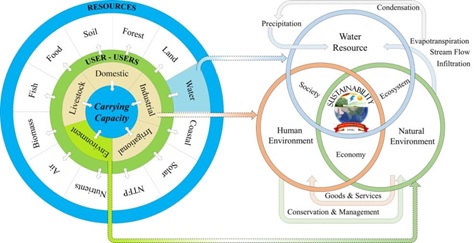
Geospatial technology refers to all of the technology used to acquire, analyse, and archive geographically referenced spatial information. Recent advances in remote sensing have empowered the geospatial domain with the availability multi-resolution spatial data at regular interval1,2. Geospatial technologies include Geographic Information System (GIS), Global Positioning System (GPS) and data acquired through space borne sensor at regular intervals (RS: Remote sensing data). Geospatial technologies aid to understand past, present and future status of landscape, impacts environmental policies and management practices, etc. Geospatial technology supports environmental sustainability through a wide range of innovative and cost effective solutions1. Fig. 1 outlines various components for the water sustainability considering resources availability, uses and users’ needs, and prudent allocation of resources within the ecosystem’s sustainability threshold1.
This article focuses on the assessment of eco hydrological footprint in the Kali River of central Western Ghats, Karnataka. Land use dynamics assessment2 using the temporal remote sensing data of four decades reveal decline of evergreen forest cover from 61.8% to 37.5% in Kali river basin during 1973 – 2016. Computation of eco hydrological indices shows that the sub catchments in the Ghats with higher proportion of forest cover with native species has better eco hydrological index as against the plain. This highlights the vital ecological function of a catchment in sustaining the hydrologic regime when covered with the vegetation of native species. The presence of perennial streams in sub-catchment dominated by native vegetation compared to the seasonal streams in the catchment dominated by anthropogenic activities with monoculture plantations.
The overall water footprint in a river basin for the sustenance of water resources (given in Fig 2) has been assessed through
(i) land use analysis to understand the structure of the river catchment and the dynamics
(ii) assessment of hydrological footprint
(iii) assessment of ecological footprint
(iv) quantification of ecohydrological footprint
(v) assessment of eco-hydrological status.
Kali River catchment physical integrity is altered with the implementation of unplanned developmental projects such as the construction of series of dams, Kaiga nuclear power plant, Dandeli paper mill, etc. leading to large-scale land cover changes3 evident from the decline of forests from 84.6% (1973) to 54.9% (2016) and the reduction of evergreen forests from 61.7% to 38.5%. Now the River Kali has over 58% forest cover. These structural alterations of the landscape in the basin have altered the natural hydrologic regime.
Runoff in the basin is about 2227 million cubic meters and Infiltration of 7696 million cubic meters. Presence of rich evergreen forest cover in the Ghats, has contributed to higher infiltration i.e., about 4035 million cubic meters. Ground water recharge in the catchment ranges between 125 mm to 880 mm in the plains and Ghats, on an average 460 mm in contributed to ground water recharge accounting to 2360 million cubic meters. Water available in the hypomorhpic layer is about 5022 million cubic meters. Sub surface flows as function of pipeflow and baseflow was estimated, considering the soil and geological characteristics of the region. Pipeflow in the basin is about 550 Million cubic meters where as base flow is about 514 million cubic meters both together contributing to a sub surface flow of 1064 million cubic meters.
Assessment of water footprint indicates the requirement of 2309 million cubic meters for the societal and livestock demand, 3779 million cubic meters for terrestrial ecosystems and environmental flow of 987 million cubic meters (to sustain aquatic biota). The terrestrial demand is met by percolated water in hypomorphic zone, supply in the basin would be function of surface and subsurface flows which accounts 3292 million cubic meters. Ecohydrological footprint emphasizes the role of forests on infiltration and evapotranspiration capabilities. Sub-basins with higher forest cover had higher eco-hydrological index supplementing that the availability of water can satisfactorily maintain the demands, where sub-basins dominated by monoculture had low index indicates water scarcity. Agriculture water demand was found to be higher in Sub basins 1, 2, 3, 4, 5, 6, 11 (Fig. 3) with over 100 million cubic meters as against Ghats, and annual agriculture demand in the basin is about 2272 million cubic meters. Taluk wise livestock census showed of higher population in plains compared to the Ghats or Coasts, with water demand of over 1000 kilo cubic meters. Annual livestock demand in the basin is about 10.2 Million cubic meters. Domestic water requirement in the basin is about 27.1 Million cubic meters across the basin.
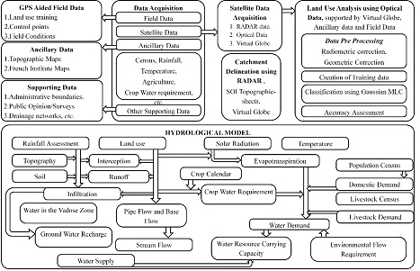
Fig. 2. Method for land use and hydrological footprint assessment
Both livestock and human population combined together has a domestic footprint of 37.3 Million cubic meters.Ecological flow in the basin is about 30% of mean annual flow. Annual average flow in the basin considering runoff and sub surface flows is about 3291 million cubic meters with the environmental flow of about 987 million cubic meters. Ecological footprint of the basin is about 7075 million cubic meters and of this 6088 million cubic meters is the water footprint in agriculture, domestic, livestock and evapotranspiration from forests. Ecohydrological status (Fig.3) assessment confirms the role of native vegetation (native forests) in reatining the water in the catchment. Hydrological footprint (Fig. 3) shows water scarce situation in sub-basins 1, 2, 3, 5 and 6 located in the eastern plains where as subbasins in the Ghats and Coasts i. e.,4, 7, 8, 9, 10, 11, 12 and 13 show sufficient water availability to cater domestic, irrigation, horticulture, livestock, and ecological needs. Presence of dense forest cover in the Ghats make it more favorable to cater most of the environmental flow demands in each sub-basin and ecological flow demands in the river downstream

Fig. 3. Eco-Hydrological Status in Kali river basin.
Kali river catchment is a habitat to very rare and endangered wildlife and endemic flora. Ecology of Kali basin is assessed through biodiversity (such as endemic flora and fauna) based on field measurements, and literature studies3,4. The flora includes most threatened and vulnerable species such as Wisneria triandra, Holigarna beddomei, Holigarna grahamii, Garcinia gummi_gutta, Hopea ponga, Diospyros candolleana, Diospyros paniculata, Diospyros saldanhae, Cinnamomum malabatrum, Myristica malabarica and Psydrax umbellate etc. Wild life includes predators such as tiger (Panthera tigris), leopard, wild dog (dhole) and sloth bear. Prey animals are barking deer, spotted deer (Axis axis), wild boar, sambar (Cervus unicolor), gaur (Bos gaurus). The region has an important elephant corridor between Karnataka and Maharashtra for about 47 elephants4. Birds include great hornbill (Buceros bicornis), malabar pied hornbill (Anthracoceros coronatus), blue winged parakeet, Nilgiri thrush, malabar lark, bulbul, thrush, etc. There are about 22 Amphibians and Ghats. This highlights the occurrence of endemic flora and fauna in catchments with the perennial water resource and sufficient hydrological footprint. The information related to biodiversity and ecology of the region were compiled through literature review and field measurements. Ecological Sensitive Regions (ESR) were delineated based on the geoclimatic, land, ecological, hydrological parameters3. ESR spatial data is integrated with hydrological status of the river (perennial, seasonal) and is presented in Fig. 4. The study confirms the ecological sensitiveness linkages with the hydrologic regime of a region with the occurrence of perennial streams in ESR 1 and 2.
The study confirms the role of native forests (contiguous interior forests) in sustaining the water evident from the occurrence of perennial streams compared to the seasonal streams in the catchment dominated by degraded forest patches. This highlights the linkages of hydrology, biodiversity and ecology with the land use dynamics in a catchment
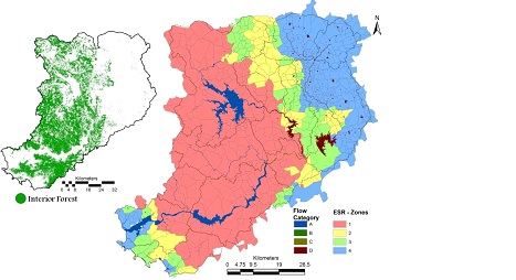
Fig. 4. Ecologically Sensitive Zones (Village wise)
Hydrological footprint shows sustained water supply catering societal and environmental demands in the catchment dominated by native forest cover of endemic flora. Inter annual variability of supply and demand foot prints indicate that the sub basins between coasts and Ghats are with perennial river streams, whereas the transition zones between Ghats and plains towards the eastern portions showed deficit of water for 6 to 10 months with intermittent and seasonal flow. Occurrence of streams with 12 months flow in the ecologically sensitive region (1 and 2) confirms of linkages of hydrologic regime with the ecological sensitiveness of a region. This highlights that streams are perennial in the catchment with forest cover > 70% and with higher endemic plant species confirming the linkage between ecology, hydrology with the land use dynamics in the catchment. This provides invaluable insights to the need for integrated approaches in the river basin management in an era dominated by mismanagement of river catchment with the enhanced deforestation process, inappropriate cropping and poor water efficiency. The premium should be on conservation of the remaining evergreen and semi-evergreen forests, which are vital for the water security (perennial streams) and food security (sustenance of biodiversity). There still exists a chance to restore the lost natural evergreen to semi-evergreen forests through appropriate conservation and management practices.Current management practices adopted by 20th century civil engineers have been contributing to the erosion of water retention capability in the catchment with severe water scarcity, evident from 279 districts in the country reeling under droughts during the last three consecutive years.
The current study provides insights of the role of forests with native species in maintaining the hydrological regime while sustaining the local demand, which is useful in the watershed (catchment / basin) management by the respective government agencies
Citation : Ramachandra. T.V., 1996. Scope for Solar Energy Devices in Kamataka State, India., Energy Studies Review Vol. 8, No. 2, pp. 1-6.
|